
⚠️ ちょ待って!年末年始の旅行、マジで天気ヤバそう…?全米 Holiday Week 天気予報 ⚠️
年末年始の旅行計画、もう立てた?✈️ ちょっと待った!
アメリカ各地で年末年始の天気が荒れる可能性 があるってよ…!
特にホリデー明けの週末は要注意 ⚠️
各地の天気と、 影響を受けそうな主要空港 をまとめたから、しっかりチェックして、 早めの対策 を!
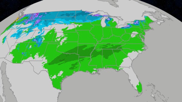
📅 月曜日: 中西部・南部は雨、ロッキー山脈は雪 🌨️

-
影響を受けそうな主要空港: ダラス、ヒューストン、カンザスシティ
-
霧: 中西部、ディープサウス、西部の一部で霧が発生する可能性あり。
- 午前中には解消される見込み だから、通勤や朝のフライトに影響があるかも?
- ルイビル、ナッシュビル、サクラメント、セントルイス、タンパは要注意!
-
雨: テキサス、ルイジアナからミシシッピ川上流にかけて雨の予報。
- テキサスからアーカンソー、ルイジアナ北部・西部、ミシシッピ では、洪水や激しい雷雨 の可能性も!
- 道路の冠水に注意して、時間に余裕を持って行動しよう。
- ダラス・フォートワース、ヒューストン 発着のフライトは雷雨による遅延に注意!
- ロッキー山脈北部: 雪と強風で道路が滑りやすくなるかも。山の峠道は特に注意!
🗓️ 火曜日: 東海岸は雨、北部平原は雪 ❄️

-
影響を受けそうな主要空港: アトランタ、シカゴ、ニューヨーク、フィラデルフィア、シアトル、ミネアポリス(遅延)、ワシントンD.C.
-
霧: 東海岸沿い (北東部~フロリダ) と中西部で霧が発生する可能性あり。
- 東海岸の主要ハブ空港やシカゴ 発着のフライトは遅延に注意!
-
雨: 中西部・南東部から東海岸にかけて雨が広がる予報。
- 南東部では雷雨の可能性も。
-
北部平原: ダコタ州の一部からミネソタ州北部にかけて、風を伴った雪が降る予報。
- 州間高速道路94号線 (ツインシティズ北西部~ノースダコタ) や、29号線 (ノースダコタ、サウスダコタ北東部) は通行困難になる可能性あり。
- ツインシティズ では夜に雨が雪に変わり、路面が滑りやすくなるかも。
- 北西部: ワシントン、オレゴンで雨や山間部の雪。夜にはアイダホ北部、モンタナ極西部にも広がる可能性あり。
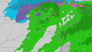
🪅 水曜日: 東部は雨、五大湖周辺は雪 ☃️

-
影響を受けそうな主要空港: ボストン、ニューヨーク、フィラデルフィア、シアトル、ワシントンD.C.
-
雨: 東部では、寒冷前線の影響で雨が降る可能性あり。
- 北東部の主要ハブ空港発着のフライトは遅延に注意!
-
五大湖周辺: 五大湖西部の雪地帯 (ミシガン北部・西部、ウィスコンシン北部) から、東部の雪地帯 (オハイオ北東部、ペンシルベニア北西部、ニューヨーク南西部・北部) にかけて、激しい湖水効果雪と強風 が広がる予報。
- この地域での移動は危険を伴う可能性大!
- 北西部: 引き続き雨とロッキー山脈の雪に注意。
- ワシントン西部とオレゴンの一部 では、局地的に大雨 を降らせる 大気 River 現象 になる可能性も。
🦃 感謝祭当日: 五大湖周辺は雪、北西部は雨 ☔️

-
影響を受けそうな主要空港: シアトル
-
五大湖周辺: 引き続き、激しい湖水効果雪と強風 が続く予報。
- クリーブランドからバッファロー付近の州間高速道路90号線、シラキュース (ニューヨーク) 北部の81号線、インディアナ北部の80/90号線、ミシガン西部の94号線と196号線 では、ホワイトアウト になる可能性も!
- 北西部: ロッキー山脈北部やモンタナ州の平原地帯では雪が降る可能性あり。
- 太平洋岸北西部では、雨や強風に注意。
🛍️ 金曜日: 五大湖周辺は雪、北部平原は雪、南部は嵐 ⛈️

-
影響を受けそうな主要空港: ダラス・フォートワース (遅延)、ヒューストン (遅延)、カンザスシティ
-
五大湖周辺: 湖水効果雪が続くため、引き続き移動は危険。
- ニューイングランド北部でも雪が降る可能性あり。
-
北部平原: モンタナから北部平原 (ダコタ州~ミズーリ渓谷) にかけて雪が広がる予報。
- 夜には中西部上部にも雪が広がる可能性あり。
- 南部: カンザス、ミズーリ南部からテキサス、ルイジアナにかけて、金曜日の夜に雷雨が発生する可能性あり。
- テキサスの主要空港ハブ では、夜間のフライト遅延 に注意!
週末: 土曜日 & 日曜日 🚨 まだまだ予断を許さない状況 🚨


週末の天気は、まだ予測が定まっていない みたい。
特に日曜日は、予報モデルが大きく異なっている から、最新情報を要チェック!
-
土曜日:
- 影響を受けそうな主要空港: シカゴ、デトロイト、ダラス・フォートワース、ヒューストン、カンザスシティ
- 中西部: 雪、みぞれ、凍雨など、冬の嵐になる可能性あり。
- 南部: 雷雨の可能性あり。
- ロッキー山脈: 雪が降る可能性あり。
- 日曜日:
- 予測が非常に困難 な状況。
- 東海岸で雨、ニューイングランド北部で雪、中部は雪と雷雨、南西部は雨、東部は乾燥…と、様々なパターンが考えられる。
🤔 まとめ: 最新情報を常にチェック!臨機応変な対応を心がけて!
年末年始の旅行、せっかくの機会だから楽しみたいよね!
最新の天気予報を常にチェック して、 時間に余裕を持った計画 を立てることが大切 🙆♀️
Where Mother Nature Plans To Disrupt Travel
Thanksgiving week has arrived. Unfortunately, the weather may not cooperate in parts of the country, especially the weekend after the holiday.
Here’s what you need to know for the weather forecast:
Monday
Major airports that could be impacted during the day: Dallas, Houston, Kansas City
Fog: Areas of fog will blanket parts of the Midwest, Deep South and a few areas of the West. In most of these areas, the fog should lift by mid-morning, so this may only affect the morning commute or any morning flights in Louisville, Nashville, Sacramento, St. Louis or Tampa.
Soaked central: Rain is expected from Texas and Louisiana to the upper Mississippi Valley. Flooding rain and a few severe thunderstorms are possible from Texas to Arkansas, northern and western Louisiana into Mississippi. Watch for flooded roads and leave extra time to get to your destination. This may lead to thunderstorm-related flight delays at Dallas-Ft. Worth and eventually, Houston.
Northern Rockies snow: Some snow and increasing winds are possible in parts of the Northern Rockies that could lead to slippery roads, especially over mountain passes.
(For even more granular weather data tracking in your area, view your 15-minute details forecast in our Premium Pro experience.)
Tuesday
Major airports that could be impacted: Atlanta, Chicago, New York City, Philadelphia, Seattle, Minneapolis (late), Washington, D.C.
Fog: Once again, there could be areas of fog to deal with Tuesday morning, this time up and down the Eastern Seaboard from the Northeast to Florida, but as well in parts of the Midwest. This could lead to morning flight delays at many major East Coast hubs, as well as Chicago.
More widespread rain for the eastern half of the U.S.: Rain is expected to spread from the Midwest and Southeast early to the East Coast by the end of the day. Some thunderstorms are possible across the Southeast in the areas shaded in darkest green above.
Snow in the Northern Plains: Wind-driven snow is expected in parts of the Northern Plains from parts of the Dakotas into northern Minnesota. This could lead to challenging travel on Interstate 94 northwest of the Twin Cities into North Dakota and Interstate 29 in North Dakota and northeast South Dakota. Rain may turn to snow in the Twin Cities Tuesday night, leading to some slippery travel.
Northwest, again: Another storm system may bring rain and mountain snow to Washington and Oregon, then into northern Idaho and far western Montana late.
Wednesday
Major airports that could be impacted: Boston, New York City, Philadelphia, Seattle, Washington, D.C.
Rain may linger in East: For the peak travel day, showers may flare up ahead of a cold front in at least parts of the East That could lead to some flight delays out of the major Northeast hubs.
Lake-effect snow: Heavy lake-effect snow and strong winds will spread from the western Great Lakes snowbelts (northern and western Michigan, northern Wisconsin) Wednesday into the eastern lake snowbelts (northeast Ohio, northwest Pennsylvania, southwest New York, upstate New York) overnight Wednesday night. Expect dangerous travel in these areas.
Northwest still wet: Pacific Northwest rain and northern Rockies snow are expected, which could lead to slippery roads, particularly over mountain passes. This Northwest system could be an atmospheric river event with locally heavy rain possible in parts of western Washington and Oregon.
(192-hours: Further beef up your forecast with our detailed, hour-by-hour breakdown for the next 8 days – only available on our Premium Pro experience.)
Thanksgiving Day’s Forecast
Thanksgiving Day
Major airports that could be impacted: Seattle
Lake-effect snow: Bands of heavy lake-effect snow and strong winds will continue in the Great Lakes snowbelts. Expect whiteout conditions in these narrow, localized lake-effect bands affecting stretches of Interstate 90 from Cleveland to near Buffalo, Interstate 81 north of Syracuse, New York, Interstates 80/90 in northern Indiana and Interstates 94 and 196 in western Michigan.
Rain and snow for Northwest: Snow may blanket the northern Rockies and possibly the adjacent High Plains of Montana. In the Pacific Northwest, expect some showers and possibly strong winds in western Washington and Oregon.
Friday
Major airports that could be impacted: Dallas-Ft. Worth (late), Houston (late), Kansas City
Another day of lake-effect snow: Lake-effect snowbands will persist, especially in the eastern and northern Great Lakes snowbelts, with dangerous travel likely. Some other wrap-around snow showers are possible in northern New England.
More Northern Plains snow: Snow will spread out of Montana into the Northern Plains from the Dakotas to the Missouri Valley. Friday night, that snow may spread into parts of the upper Midwest.
More South storms: Showers and thunderstorms may break out Friday night from Kansas and southern Missouri to Texas and Louisiana. Some of those may have heavy rainfall and could lead to nighttime flight delays at the major Texas airport hubs.
Saturday
This forecast has considerable uncertainty. Check back with us at weather.com for the latest forecast updates.
Major airports that could be impacted: Chicago, Detroit, Dallas-Ft. Worth, Houston, Kansas City
Midwest wintry mess: Snow, possibly some sleet and freezing rain, may move through parts of the Mississippi Valley and Great Lakes. This could lead to both slippery roads and flight delays, including at Chicago-O’Hare and Detroit.
South storms: Thunderstorms with heavy rain, and some possibly severe, may rumble across the South from Oklahoma and Texas to the lower Mississippi Valley. This could lead to local flash flooding and flight delays at both Dallas-Ft. Worth and Houston.
Rockies snow: At least some light snow is possible in the Rockies possibly as far south as Colorado or New Mexico.
Sunday
This forecast has major uncertainty right now. The map above shows our current forecast.
Right now, weather forecast models vary widely in Sunday’s weather across the country, ranging from East Coast rain and northern New England snow, with little else, to a mess of snow and thunderstorms in the central U.S., showers in the Southwest and a dry East.
Check back with us at weather.com for the latest forecast updates in the coming days as this forecast comes into focus.


コメント