
標高8,848mの絶景!ドローン映像でエベレスト北東稜ルートを疑似体験してみた
「いつかエベレストに登ってみたい!」
そう夢見たことはありませんか?
でも、時間もお金もかかるし、何より命がけ…。
なかなか一歩を踏み出せない人も多いはず。
そんなあなたに朗報です!
なんと、ドローン映像でエベレスト北東稜ルートを疑似体験できるんです!

まるで自分が空を飛んでいるみたい!
エベレスト北東稜ルートって?
エベレストには、ネパール側の南東稜ルートと、チベット側の北東稜ルートの2つの主要ルートがあります。
南東稜ルートは、ヒラリーステップなどの有名なランドマークがあり、多くの登山家が利用するルートです。
一方、北東稜ルートは、南東稜ルートに比べて知名度は低いものの、毎年100人以上の登山家が挑戦するルートなんです。
プロのカメラマンが捉えた、息をのむ絶景
今回ご紹介するドローン映像は、中国の高地専門カメラマン、馬春林(Ma Chunlin)氏が撮影したもの。
標高6,500mを超える地点からドローンを飛ばし、北東稜ルートをワンカットで撮影することに成功しました。
完璧な映像を求めて、入念な準備を行ったそうです。
映像は、日の出の時刻に合わせてスタートし、カメラワークも完璧に計算されています。
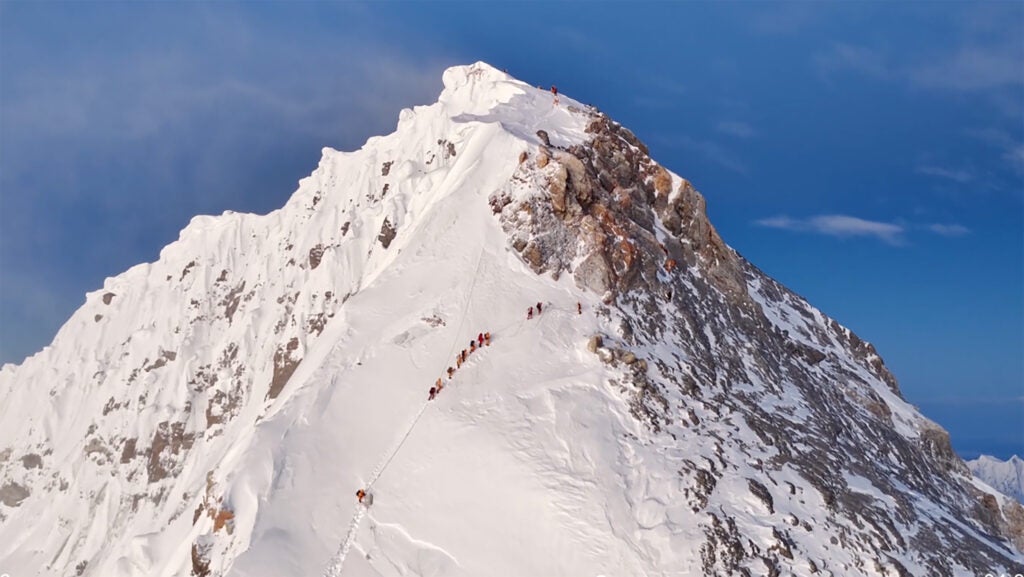
雪、岩、氷が織りなす壮大な景色は、まるで自分がエベレストを登っているかのような臨場感!
4分30秒の感動をあなたに
さあ、あなたも4分30秒の空の旅へ出発しましょう!
映像では、登山家たちが苦労して辿り着くキャンプ地の様子や、山頂直下のイエローバンドなども見ることができます。
圧巻のドローン映像はこちら!
まとめ
エベレスト北東稜ルートのドローン映像はいかがでしたか?
なかなか行くことのできない場所の景色を、手軽に体験できるのは嬉しいですよね。
この映像を見て、少しでも冒険心をくすぐられたなら幸いです。
いつか、あなたもエベレストの頂に立てる日が来るかもしれません!
Hardcore Mount Everest geeks (myself included) can close their eyes and envision route connecting Nepal’s Base Camp to the summit.
The Southeast Ridge ascent passes the familiar landmarks that, over the decades, have come to define the peak: Khumbu Icefall, Western Cwm, Lhotse Face, South Col, and of course the Hillary Step. And last year, a drone video made by Chinese manufacturer DJI helped fans view every step up the ascent in a thrilling eight-minute clip.
But what about Mount Everest’s Northeast Ridge route? The peak’s other flank, which sits in Tibet, does not have the same level of name recognition as the southern route. This is despite the fact that 100 or so climbers ascend the northern flank each year, including teams led by British-American guide Adrian Ballinger, and Austrian guide Lukas Furtenbach.
But a new high-definition drone video may help Everest fanatics who will never set foot on the peak better understand the nothern route.
In June, Chinese high-altitude photographer Ma Chunlin published a crips video that captures the north slope ascent in a single and uninterrupted cut.
According to China Global Television Network, a state-run news outlet, Ma Chunlin hiked to the advanced base camp in Tibet at 21,325 feet and then waited for clear skies and calm winds to launch his draft.
“The shoot had to begin at sunrise, timed down to the exact minute, and follow the climbing route precisely, without a single error in camera movement,” the story states.
I wholeheartedly encourage you to watch the 4:30 clip—it’s stunning overhead images capture the mixture of snow, rock, and ice that climbers must navigate on the way to the top. It showcases the seemingly precarious spots of Camp I on a snow-covered ridge and Camp II in a wind-sept slope, as well as the iconic yellow band just below the top. No, it’s still not as cool as the 2024 virtual reality film The Quest: Everest VR. But it’s definitely a welcomed addition to the growing collection of high-altitude Everest footage.


コメント